DispGen: Difference between revisions
Thunder4ik (talk | contribs) m (clean up, replaced: See Also → See also) |
Thunder4ik (talk | contribs) m (→top: Unicodifying, replaced: [[Image: → [[File:) |
||
| Line 1: | Line 1: | ||
[[ | [[File:DispGen UI.png|thumb|right|300px|User Interface.]] | ||
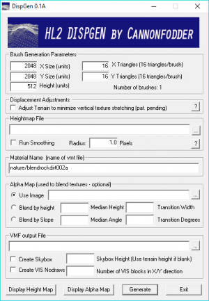
This program will create a [[Half-Life 2]] [[displacement]] map from a {{wiki|heightmap}} image. It can read common image formats along with 16-bit grayscale [[Wikipedia:Tagged Image File Format|TIFF]] and [[Wikipedia:Portable pixmap|PGM]] images. | This program will create a [[Half-Life 2]] [[displacement]] map from a {{wiki|heightmap}} image. It can read common image formats along with 16-bit grayscale [[Wikipedia:Tagged Image File Format|TIFF]] and [[Wikipedia:Portable pixmap|PGM]] images. | ||
Revision as of 23:05, 6 January 2024
This program will create a Half-Life 2 displacement map from a ![]() heightmap image. It can read common image formats along with 16-bit grayscale TIFF and PGM images.
heightmap image. It can read common image formats along with 16-bit grayscale TIFF and PGM images.
It uses a ![]() bicubic interpolation scaling algorithm. This generates a better image if the size of terrain is significantly different from the size of the texture image.
bicubic interpolation scaling algorithm. This generates a better image if the size of terrain is significantly different from the size of the texture image.
Alpha maps can be generated using images, based on the height of the texture or based on the slope (0° to 90°)
![]() DispGen includes an algorithm (jokingly described as 'pat. pending') for fixing texture stretching on the vertical parts of the terrain.
DispGen includes an algorithm (jokingly described as 'pat. pending') for fixing texture stretching on the vertical parts of the terrain.
Note: This user found an issue using .vmf files generated by Dispgen. The map would not save user visgroups. When re-opened all user visgroups would be erased (though the content of the visgroups would not be erased). Any content inside user visgroups that was saved while the visgroup was unchecked was automatically placed in an "_orphaned hidden" user visgroup by Hammer. The solution was to copy the displacement brushes out of the Dispgen-generated .vmf file and paste them into a new .vmf file made from scratch.
Cannonfodder's other source engine tools
See also
- DispGen homepage
- Digital Elevation Models - tutorial on converting publicly available terrain heightmaps of the
 United States into Source displacement maps.
| |||||||||||||||||||||||||||||||||||||||||||||||||||||||||||
